Shenandoah River fall foliage cruises through the Blue Ridge Mountains area: An Evidence-Based Seasonal Guide
The phrase “Shenandoah River fall foliage cruises through the Blue Ridge Mountains area” generally describes an autumn river outing viewed from a canoe, kayak, tube, raft, or guided float rather than a regularly scheduled motorized sightseeing vessel. Commercial recreation on the river is primarily paddle-based, with foliage experienced from the water as the Blue Ridge and valley forests change color. 4
What a Shenandoah River foliage cruise usually involves
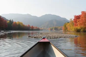
The Shenandoah River’s commercial visitor experiences center on canoeing, kayaking, tubing, rafting, and guided paddling. Outfitters market trips that range from short beginner floats to longer day outings, so the term “cruise” should not automatically be interpreted as a large boat tour with fixed sightseeing narration. 4 The river’s generally gentle character allows participants to observe wooded banks, gravel bars, wildlife, and mountain horizons at a slower pace than a road-based tour. 2
Autumn conditions can make the river especially visually distinctive. Local reporting describes clearer water, cooler mornings, fewer summer crowds, and reflections of red, orange, and gold foliage on calm sections. Deer, bald eagles, great blue herons, belted kingfishers, and migrating birds are among the wildlife reported along the river corridor, although sightings are not guaranteed. 1 2
Where the river meets the Blue Ridge landscape
Three principal recreational sections are commonly identified: the North Fork, the South Fork, and the main stem formed where the forks meet near Front Royal. The South Fork near Luray and the North Fork near Front Royal are among the most accessible areas for fall paddling. 2 Downriver Canoe Company serves river-trip areas associated with Front Royal and Bentonville, while Shenandoah River Outfitters operates in the South Fork area near Luray. 5 6
Shenandoah River State Park provides river access, a boat launch, camping, hiking, scenic facilities, and approximately 5.2 miles of river frontage. 3 The park can therefore function as a land-based companion to a river itinerary, particularly for visitors who want overlooks or trails in addition to time on the water. The broader valley is framed by the Blue Ridge and Massanutten Mountain landscapes, with farmland and forested banks shaping many river views. 2
How fall color timing changes by elevation
Autumn color usually begins at higher elevations and progresses downward toward the river valley. Local foliage guidance places early changes along Skyline Drive and ridge trails in late September, with higher-elevation peak color commonly occurring between October 7 and October 20. 1 A separate regional guide describes the tallest ridges, including elevations above approximately 3,500 feet, as turning before lower areas. 3
Valley foliage generally develops later. Local outfitter guidance places peak color along lower elevations and river corridors between approximately October 18 and early November, while broader regional guidance identifies mid-October through the first week of November as a common Shenandoah peak period. 1 3 Weather can shift the calendar, so the Virginia Department of Forestry’s seasonal reports and the National Park Service’s weekly fall color information are more reliable than treating any single date as fixed. 1 3
Trip formats and representative river sections
Short beginner floats are available on portions of the South Fork. One documented itinerary runs from Bealer’s Ferry to Foster’s for approximately three miles, with shuttle transportation, basic instruction, a safety video, and a river map. 4 Another documented outing covers the Bixler’s Bridge to Bealer’s Ferry section over about four hours, with a gentle current and Class I to II riffles described for the route. 5
Longer day trips can extend to approximately eight miles and may be paired with a visit to Luray Caverns, while guided fishing floats near Strasburg are designed for one or two anglers and may last about eight hours. 6 7 These formats differ in purpose: a foliage-focused float emphasizes scenery and pacing, whereas fishing or longer-distance trips add equipment, route logistics, and time on the water. The appropriate format depends on experience, weather, river flow, and physical tolerance.
Water levels, weather, and practical risks
Autumn river conditions are not static. Recent rainfall, water temperature, river level, current speed, and submerged or shoreline hazards can affect whether a route is suitable on a particular day. The U.S. Geological Survey maintains real-time streamflow and water-level information for Shenandoah monitoring stations, and the National Weather Service provides current weather information relevant to planning. 7 10
Documented paddling guidance recommends river shoes or sturdy strapped footwear instead of loose flip-flops, waterproof protection for vehicle keys, compact coolers for water and snacks, and attention to changing flows after rainfall. 5 Some routes involve shuttles, deposits associated with returning from the river, and vehicle recovery at a separate landing, creating logistical friction that should be understood before departure. 4 Pack-out practices, avoidance of shoreline damage, and cleaning gear between waterways also reduce impacts on the Chesapeake Bay watershed and help limit invasive species. 5
Combining a river outing with Blue Ridge sightseeing
Skyline Drive follows the crest of the Blue Ridge for 105 miles through Shenandoah National Park and provides overlooks that can be combined with a valley river outing. 1 Because color moves from ridge to valley, a practical itinerary may pair higher-elevation overlooks earlier in the season with lower river corridors later in October or during the first part of November. This elevation-based approach is more dependable than assuming every landscape reaches peak color simultaneously. 3
Luray, Front Royal, and the Shenandoah River State Park area provide practical bases for combining river access with scenic drives, hiking, caverns, and overlooks. 9 Visitors seeking a non-water alternative can also consider the Virginia Scenic Railway’s October Autumn Special excursions, which travel through farmland, wooded hills, mountain scenery, and Shenandoah Valley landscapes from Victoria Station in Goshen. 8 That rail experience is distinct from a river cruise, but it illustrates the region’s broader range of foliage viewpoints.
Sources
- National Park Service, Skyline Drive: https://www.nps.gov/shen/planyourvisit/skyline-drive.htm
- Virginia Department of Wildlife Resources, Shenandoah River: https://dwr.virginia.gov/waterbody/shenandoah-river/
- Virginia State Parks, Shenandoah River State Park: https://www.dcr.virginia.gov/state-parks/park-shenandoah-river
- Shenandoah River Adventures: https://www.shenandoahriveradventures.com/
- Downriver Canoe Company: https://downriver.com/
- Shenandoah River Outfitters: https://www.shenandoahoutfitters.com/
- U.S. Geological Survey Water Data: https://waterdata.usgs.gov/monitoring-location/01631000/
- Virginia Scenic Railway, Fall Excursions: https://www.virginiascenicrailway.com/experiences/fall-excursions/
- Virginia Is for Lovers, Shenandoah Valley: https://www.virginia.org/places-to-visit/regions/shenandoah-valley/
- National Weather Service: https://www.weather.gov/
Authored by MistyMountainView team